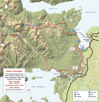
The Kepler Track was the second of the three we walked. It starts and ends across Lake Te Anau from the town of the same name (where I would now be living if there weren’t a few people in this neck of the woods I rather like to see). And although the area had been walked (and even skiied) for many years, the current Great Walk was only opened in the summer of 1988, explicitly to ease strain on the Milford (the so-called “finest walk in the world”) and the Routeburn (which many New Zealanders believe is finer).
There are several types of formal tracks in New Zealand. The best known are what we were on—the Great Walks. These are described by the Department of Conservation as “Easier Tramping Tracks … well-formed and easy to follow with plenty of direction signs. All major streams and rivers have bridges. These are the best sort of tracks for people with limited multi-day tramping experience … Moderate fitness required.” So, lovely but unchallenging. And this was absolutely accurate.
Tramping Tracks “… offer challenging tramping on mostly unformed surfaces. Moderate to high level backcountry skills and experience are required, including navigation, river crossing and survival skills. Trampers need to be completely self sufficient … Good fitness required ….” So, Mark’s TGO Challenge.
Routes are “unformed, and may be rough and steep … Suitable for highly experienced trampers only.” So, Martin’s TGO Challenge.
As you would expect from these definitions, the Kepler is beautifully built and maintained—almost unbelievably so to people used to negotiating the rocky and boulder-strewn trails in New Hampshire’s White Mountains.
The treadway was apparently constructed by machinery airlifted in by helicopter, and machines are still used for serious maintenance. (I’m imagining a sort of even-more-miniature Bobcat, but I’m not sure) It’s not exactly a wilderness experience or a challenge. What it is, for much of the second day (that big bump, below) and occasionally before and after, is stunningly beautiful.
That second day is well above tree line, and also well above the deep blue Lake TeAnau and its South Arm. Above, along a great sweep of the horizon, are jagged Sierra-style peaks, showing off twinkling waterfalls and bright patches of snow and ice, all of which you get a quick glimpse of in the little video two posts ago. Quite beautiful, and a very fine walk by just about anyone’s standards.
After a steep descent, we spent the night at Iris Burn Hut. (I kept imagining a hearty local woman who lived along the stream and gave it her name, but, of course, the hut is named after a brook—a burn.) The ranger here gave us a bit of a talking to about watching our steps up above, since, he joked, he and his colleagues were not paid enough to come out and rescue us—only enough to feel some distant concern. (The DOC rangers do come out as needed, of course, though they rely to a much greater extent than our Northeastern U.S. Search and Rescue people on helicopters.)
On the third day, we wandered further down Iris Burn to the Moturau Hut, where most of us dove into the lake, which is overlooked by more impressive and lofty eminences. Certainly one of the prettiest places I’ve ever instantly, and happily, acquired goosebumps.


The diagram makes it look rather extreme, Mark.
I must index my TGO 2010 postings BTW!
As in last Wednesday's post, you've got to imagine the profile stretched to perhaps twice its length to get a realistic feel for the steepness of the walk. It wasn't really Mt. Everest.